Friday, November 9, 2012

Index of this Amazing Tour

I am sure there is some easy, efficient way to list all the posts within this blog, but I have not been able to discover it!

This page serves as an index to the entire site, with the postings listed in date order, from my preparations in mid-July through the entire 14-day trip through South Africa.

To start off, here is a graphic representation of the many tour stops we made via Google Maps:


View SA Partner Tour 2012 in a larger map


·                                 Preparations

•     Wednesday, July 11, 2012


•     Thursday, July 12, 2012

•     Monday, July 16, 2012

•     Tuesday, July 17, 2012


·                                 Wednesday, July 18, 2012


·                                 Thursday, July 19, 2012


·                                 Friday, July 20, 2012


·                                 Saturday, July 21, 2012


                              Sunday, July 22, 2012


·                                 Monday, July 23, 2012


·                                 Tuesday, July 24, 2012


·                                 Wednesday, July 25, 2012


·                                 Thursday, July 26, 2012


·                                 Friday, July 27, 2012


·                                 Saturday, July 28, 2012


·                                 Sunday, July 29, 2012


·                                 Monday, July 30, 2012

Sunday, September 2, 2012

REFLECTIONS

The tour has ended, but there isn’t a day that goes by without some thoughts of the places I’ve seen and the experiences I’ve had.  I didn’t think it would be so hard to put it all into perspective, but it is. 

The best I can do is approach my reflections in levels.

First, there’s just the sheer breadth and depth of all the places we went to.   By my count, we traveled to twenty-six sites – and that’s not counting the places we stayed, or the many excellent restaurants we experienced or the several stops we made to shop!   I searched for a way to condense these sites into some sort of frame of reference and I think I found it.  The map below is from a site called Tripline.  By plugging in the locations of each site, Tripline plotted our tour stops on a map.  By adding dates, the tool sequenced the stops to give a sense of where we traveled and how far we journeyed.  Add to all that an awesome soundtrack and the ability to add narrative text and images, and you have the following multimedia experience:

So, in a little over two minutes, you got just a taste of our 14-day countrywide tour.


Now, consider that at each and every one of those sites I came away with new knowledge that helped me fill in some pieces of this complex puzzle that is South Africa.  At the same time, every one of these sites raised questions and gave me something more to consider. 
More on this to follow...

Monday, August 27, 2012

Day 14 (cont’d) & Day 15 – The Journey Back Home

After our intense morning at Shikaya, we had no time to sit back and reflect on all that we had learned.

We had already packed our bags and brought them with us in the van to Shikaya.  Now, almost noon, it was time to head to the Cape Town airport to begin the long, almost 9000-mile trip back to the United States.

Our route had three legs:

  • Cape Town to Johannesburg
  • Johannesburg to JFK Airport in New York
  • New York to Boston, Massachusetts

When you see it on a map, it looks about as long as it felt:


(Map created using Google Maps!) 

As we took off from Cape Town, it was such a clear day and the view was so incredible, I managed to get a few pictures:

(Cape Town harbor with Table Mountain in the background)

(Robben Island)
Oddly enough, the return trip did not seem as long as the flight down.  It wasn’t that I was used to sitting on a plane for 15 hours –  who could be?  I think it might have had something to do with all the experiences swimming around my head.  I still had many blog entries to write up, so I managed to write down about 10 notebook pages of rough drafts before I finally gave up.  That took up about four hours.  This time I watched four movies: The Avengers, The Truman Show, Men in Black, and a documentary on Nelson Mandela).  There went another five hours.  Let’s not forget five more chess games against the computer (final score: 2 wins, 1 loss and 2 draws)!... That got me through three hours.  Factor in a few long naps, about ten jogs around the aisles of the plane and, of course, two meals, and you’ve just about totaled 15 hours.

If I could pass along one bit of travel advice, it would be:  take note of flights from Johannesburg to the USA.  South Africa Airlines has a policy where every passenger is patted down and their carry-on bags are searched.  This happens as part of your pre-boarding ‘check-in’  - in other words, AFTER you go through security and right before you get on the airplane.  What makes it particularly annoying is that they ask passengers to get into separate lines, according to gender.  This was NOT very well advertised by any signs!  So, when they made the pre-boarding announcement, of course, many couples stood in line side-by-side and then were sent to the back of their respective gender’s line because they were in the male or female line together.  Lucky for me, I was warned ahead of time by Brenna, our ever-vigilant tour queen.  If not, I probably would have followed whoever was in front of me and been required to get out of line!  Just a word to the wary…

By the time we touched down at Logan Airport in Boston, made it through Customs and retrieved our bags, it was 10:30 am EST on Tuesday, July 31.  We had completed a return trip that started in Cape Town, South Africa at noon local time (or 6:00am EST) on Monday, July 30.  So, we had been traveling (in route by van or plane, or waiting in an airport) for about 28.5 hours!  

Whoa.

Sunday, August 26, 2012

Day 14 – Shikaya

This was our last day of the tour – actually just a half-day (as we started heading home by noon) – but there was still one more stop!

After our last two days exploring South Africa’s natural beauty at the Cape of Good Hope and the Solms-Delta winery, we turned our attention back to the world of education.

We made our way about 10 minutes north to an area called the Gardens. Here, in a small nondescript building, we found the Shikaya organization. Shikaya is a non-profit organization that creates programs to support teachers and students. Their lofty goal is to help “create a South Africa in which young people in schools are inspired and supported to become responsible citizens and future in our democracy, valuing diversity, human rights and peace.”

We were introduced to Dylan Wray, Shikaya’s executive director, and Lauren Daniels, their office manager. We spent the morning at Shikaya’s Cape Town office, where Dylan was eager to explain about their current projects and initiatives.

Shikaya’s core project is Facing the Past, an initiative formed through collaboration with Boston’s Facing History and Ourselves organization. Using Facing History’s model of examining historical events in the context of individual and group choices, students come to understand how decisions were made while under Apartheid. The aim of the project is get students to see how the right choices in the future will lead to a better South Africa. Going strong for eight years, the Facing the Past program has trained hundreds of teachers, who have in turn reached tens of thousands of students. As a teacher who has been a part of the Facing History methodology for six years, I can attest that it is a powerful model. The Choices in Little Rock unit that I use is one that really resonates with my eighth grade students each and every year.

Dylan was a strong advocate for Shikaya’s goal of creating well-informed young people and, hence, responsible citizens. He told us that this can only be done when South Africans have “deep, safe discussions about our past with people who don’t look like us.” This was an approach used by the Truth and Reconciliation Committee (TRC) in the 1990s – and led Shikaya to create a two-day event called Teaching the TRC, to help educators understand the complexities and emotions of the TRC – and hopefully pass those lessons along to their students. There is an excellent write-up of this event here. http://shikaya.org/uncategorized/teaching-the-trc/ It was so interesting to hear these sentiments from Dylan, as they seemed to be an echo of what John Gilmour of the LEAP program told us just three days before about creating an ‘informed South African citizenry’.

Dylan told us that Shikaya is making strides to do more than educate teachers, and in turn students, about a better South Africa. Through a program called SA2030, teams of high-school students created research proposal on solutions to some of South Africa’s toughest problems. Utilizing team-building, oral and written communication skills as well as a formal presentation component, this program gets South Africa’s youth directly involved in addressing real national issues. The top six groups presented their ideas to a panel of distinguished South Africans, including (among others) Denis Goldberg, who was one of the eight ANC members sentenced to life imprisonment with Nelson Mandela in 1964. Video clips of the top SA2030 presentations can be found here.

(Just a quick side-story on Denis Goldberg from Dylan: Denis, who is white, was asked to speak to a group of township youth on his work with the ANC in the days of Apartheid. The students, who had little background on Denis’ role with the ANC, thought Denis was against the blacks and asked him why he wanted to put Mandela in jail!)

In addition to SA2030, Shikaya also responded to the xenophobic attacks that started in a township outside of Cape Town in 2007 and escalated across the nation the following year. Through their Up2Us program,  Shikaya developed a video called Where Do I Stand.  It follows a teacher in the Cape Town township who tries to educate his students about foreigners in South Africa and how the students, in turn, attempt to educate the community. Dylan shared this wonderful 8-minute clip from the video:


Land of Hope from Luke Younge on Vimeo.

This video and extensive teacher’s guide is available through Shikaya in the hopes that youth all over the world can learn about the roots of prejudice and bigotry, and come to understand ways to stand up for the rights of everyone.

Among the many Shikaya initiatives, we also learned about the Letters to Mandela project. This project had its roots from a 2009 letter to Nelson Mandela from a white Afrikaaner named Arno Reuvers. He wrote to say that seeing the movie Invictus finally helped him understand how Mandela was trying to bring the nation together. From this, Shikaya has created a site that asks everyone to consider writing a letter to Nelson Mandela, sharing what his legacy means to them. Letters are entered in the Letters to Mandela site and saved for others to read and help gain inspiration. To date, over three hundred letters have been entered and are available to read.

In all, we had a little over three hours at Shikaya, but I felt we had just a small sampling of the many projects and initiatives underway at Shikaya. They seemed to be driven to engage South Africa’s youth and educators in order to make a better South Africa. Everything about this organization seemed to be thoughtful and designed with a purpose. Even the name Shikaya was chosen with a specific intent. As Dylan explained, it is a word that refers to a specific type of thorn tree. On this tree, thorns come in pairs, with one thorn curved, facing backwards and the other sticking out straight. (I managed to find a nice picture of it): 

Courtesy of saphotographs.blogspot.com
The native interpretation is: the curved thorn represents your past, which you are often looking back on. The straight thorn represents your future, once you have come to grips with your past. How fitting for Shikaya and it’s mission!

When it came time to finally be on our way, Dylan presented each of us with a copy of the Where Do I Stand video as well a copy of Denis Goldberg’s memoir, The Mission: A Life For Freedom In South Africa. Mixed among these items were also flyers giving us more information about Shikaya. It was in one of these flyers that I found a quote from South African Archbishop Desmond Tutu. When I read it, I found it to perfectly sum up Shikaya’s entire goal and mission in one short sentiment:
“We don’t just want you to be smart. You could be a very smart crook. We want you to be smart and good.”

Monday, August 20, 2012

Day 13 – Solms-Delta Winery Tour

Our last full day on this amazing tour was reserved for another look at South Africa’s natural beauty. Yesterday was the Cape of Good Hope. Today, we traveled about an hour southwest to the Franschhoek Valley, better known as the Cape Winelands. Here we were treated to a farm tour, wine tasting and gourmet lunch at the Solms-Delta Winery

We could not have asked for a more perfect day. The morning was cool, but once 9am rolled around, the sun blazed and the temperatures were in the 60s. (I love ‘winter’ in South Africa!) We turned into the winery parking lot and the view truly looked like it came right from a postcard: 


If you can take your eyes off the mountain ridge in the background for JUST a second, in the foreground, you’re looking at new vines being grown on supports – to keep them straight and in line.

We were met by our tour guide, Steve, who began our tour in the winery’s Museum van de Caab. The first thing that crossed my mind as I walked toward the museum was “A winery museum? We’ll probably be learning about the ways they made wine ‘back in the day’ and how it’s changed through the years.” Not the most exciting thing for me. When I entered, however, the first thing that caught my eye was a very large wall display that had 200 black polished plaques:


Our guide told us that these plaques represented the many slaves that were part of the winery’s history. In fact, the name of the museum “van de Caab” (which is Dutch for “of the Cape”) is in memory of the generic suffix that was added to slaves’ names in the 1600s when they were born on the Cape. According to the winery’s webpage on this topic:

In everything we do at Solms-Delta we try to honour what it means to be South African, … in an honest and open way that unites all of our people, cultures, languages, musical styles, culinary traditions, flora and fauna, historic landscapes and buildings.

Here is a close-up of the top section of the display: 


You’ll notice that some plaques are all in capital letters. These act like ‘section headers’ that tell us owners’ names and then what follows is a list of any slaves they owned. Thus, Hans Silverbach – who was the first Dutch settler of this winery, owned only one slave, but that slave’s name is not known today. Following Silverbach, the next settlers of the winery must have been Christoffell Snijmann, who owned two slaves, etc. Coming from the US, where we tend to downplay the enslavement of people, Solms-Delta does not shy away from their past. They try to address the issue and say, in a sense, ‘These individuals were true contributors to our success and without them, we would not be as successful as we are today.’

The fact they they memorialized the slaves that worked on this winery does not mean that the museum had an idealized view of slave life. Posters, such as the one below, made it clear that the life of a Cape slave was cruel and they were, in the end, treated as little more that property: 


Another display reminds us that, similar to the progression of slavery in the USA, when slavery did arrive for those in Cape Town, it was not as absolute as we might think:


In addition to the variety of exhibits on slavery, other displays showcased life on a vineyard, such as one exhibit that shows types of ceramic items that were used almost 350 years ago: 


Following the museum, Steve led us toward some vineyards and explained some of the specifics of what it means to start a winery. He said that it takes approximately five to seven years of grape growing before any wine can be made. Then, one area can only continue to produce quality grapes for twenty to twenty-five years before a new location must be used. He spent a lot of time explaining how this winery has revived an old form of wine making, involving a process called desiccation. This is a method intended to increase the flavor of the grapes by pinching or squeezing the stalks so that less water arrives to the grapes. There is a detailed description of the process here.  Using desiccation, up to 40% of the water is not delivered to the grapes, but the flavor remains and is intensified due to the lack of water. The end result is a sweeter, more flavorful grape. Solms-Delta attributes their unique flavor and wine style to this process. 


Our next stop was the facility where the wine is aged. Here, we saw massive aging containers that were made of metal and the more classic oak barrels:


Susan Renyolds, Lou Ann Griswold, Susan Merrill, Brenna Decotis and me 
Beside being awed by the size of these containers, we learned two interesting things from Steve. (My apologies if this is common knowledge among wine aficionados, but it was big news to me!) First, he explained that red wines gets their color based on how long grape skins are left in the mixture. If you leave the grape skins in for 5-6 hours, you will create a rosé. If you leave them in 12-16 hours, you’ve created a Red. Second, he explained that wine aged in oak casks can stay in the bottle a long amount of time, but wine aged in the metal containers are designed to be consumed within a shorter amount of time (maybe 3-6 months).. Interesting.

We headed from this facility to a shaded area where the wine tasting part of the tour would begin. On the way, we passed one of five (I believe) vineyards. Again, the view was intense. I tried to capture it in this panorama, but I am sure I did not do it justice:


The wine tasting component to the tour was managed by our wine taster, Hilton. He brought out a variety of wines that showcased the breath of the Solms-Delta wine offerings. He gave us backgrounds, name translations and ideas on what types of food would go best with each wine. In all, we sampled nine different creations, including a unique honey wine (!Karri) and a pear cider (Perry). There were whites (Vastrap, Amalie), rosés (Lekkerwijn ), reds (Langarm, Hiervandaan), dessert wines (Koloni), and even a sparkling wine (Shiraz). All were interesting and several bottles were purchased by our tour group. My favorite was the Amalie…

Following the tasting, it was almost lunch time. We were lucky it was winter, so we were able to partake in the Sunday Winter Buffet at the winery’s amazing restaurant, the Fyndraai. Like the winery’s grounds and the wines themselves, this was NOT your ordinary buffet. The menu featured both a hot and cold buffet, each with an array of fabulous foods and flavors. In fact, the menu can be found here. The preparation was excellent and the staff was very helpful and professional. It was truly the best way to end a fabulous tour!

If you are anywhere in this region of Cape Town, treat yourself to an amazing experience and visit the Solms-Delta winery. If the weather is just right, plan to spend the entire day. You won’t be disappointed!

Thursday, August 16, 2012

Day 12 (cont’d) – The Cape of Good Hope

Even with all the intensity and emotion of our trip to Robben Island, the entire tour (ferry rides to/from, bus trip and prison tour) only took a few hours.

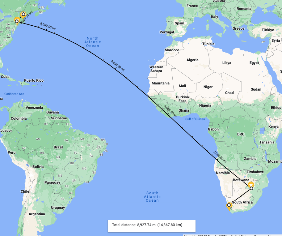
By late morning, we found ourselves on our way south – I mean really south – to almost the most southern portion of the continent. Our destination was the Cape of Good Hope, which (putting on my Geography Teacher hat for a moment), is technically the most southwestern point on the African continent. From Cape Town harbor, it was about 50 miles due south.

Ben, our ever-thoughtful driver and guide, took us on a route that hugged the coastline. He said that, with such a beautiful day, we would really see the amazing coastline in all its glory. He was not wrong! The ride by van was only about 45 minutes, but it seemed much shorter, as most of us were glued to the windows, taking in the sights.

At one point, Ben pulled off the road to let us enjoy a ‘Kodak moment’ (as he put it). We walked along a path, turned a bend and stared straight into this:


The coastal road had many twists and turns and a variety of hills and dips. The way the road snaked around blind corners and left little margin for error if you should stray too close to the guard rail, I was very glad Ben was the one doing the driving and not me! You can imagine my surprise when Ben told me that this road was the route used by a yearly bike race, called the Cape Argus PicknPay Cycle Tour.  I did some research and found that the race is 110km (68 miles) and it is not an easy road to travel. A route map from the race website has a section showing the elevation of the course:

This map really shows you what I mean by ‘hills and dips’. If you look closely, you’ll see some places where the elevation rises to almost 600 feet! Ben said this was a very popular race, with hundreds coming from out of the country to take part in it!

In almost no time, we found ourselves at the main gate of Cape Point. We each paid our admission price of $10 (actually, Brenna pre-paid for all of us!) and we were in! There was a sign announcing that the gates closed at 5pm and that there was a $60 fine for vehicles that were still in the park past closing time. The area within this park was vast - an excellent map from Cape Town Info shows just how vast:


Our destination within the park was a lighthouse almost on the tip of the Cape (the one at the very bottom of the map!). From the main gate, it took at least 20 minutes – and not driving slow! – for us to reach an upper parking area where we could walk to the lighthouse:

(Our goal – the Cape Point Lighthouse)
The distance from the parking area to the lighthouse was only about 400 feet, but the way was steep and travel was via a stone staircase. We opted not to take the electric tram car and walk instead…Twenty minutes later, at the top, we wondered if the tram car might not have been a wiser choice!

(Looking down from the lighthouse back at where we started our climb)

No matter what route you took to the top. The view was something so stunning it almost looked fake:


The long ridge of rock and earth is the place where two oceans come together. On the left, facing west, you are looking at the Atlantic Ocean and on the right, facing east, is the Indian Ocean. (NOTE: My picture doesn’t do justice to what we saw from this point. For something better, please check out this fabulous moveable aerial panorama from AirPano.com!


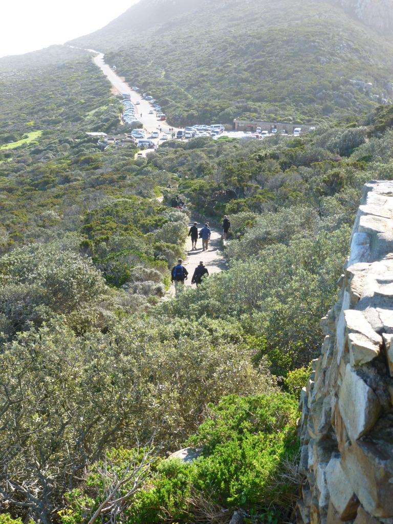
After circling the exterior of the lighthouse, we began the walk back down. When we reached the parking area, however, there was no Ben and no van. It hit us that we told Ben we would meet him in the lower parking area. When he explained that the ‘walk’ from upper to lower areas would entail a 50-minute hike, we just nodded and said “Sure – we’ll see you there.” I am sure he was thinking “Tourists…” as he drove away…

Our hike was actually challenging, as we had to climb up and over a rocky hill and down a long, winding flight of wooden stairs that were hammered into the terrain. If there was one saving grace, it had to be the surrounding view. It was as almost as amazing as the view from the lighthouse. Here are just a few examples:

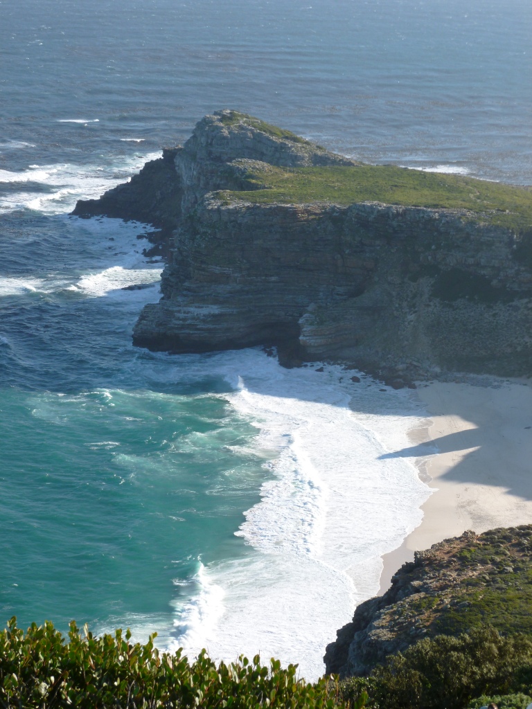
We had to walk past this cliff and beach – probably close to 600 feet high:


To give you a sense of just how high this is, two of our group decided to ‘pop’ down there, via a switch-back staircase:


When they got to the bottom, I took this shot of them on the beach:

 (In case you can’t see them, I’ve circled them)

By the time we got to the other side of these cliffs, we were so far away from the giant lighthouse we started from that it looked like a toy in the distance:


After passing the cliffs, we had to make it over this rocky ridge:


There was a walking path marked out by rocks, but that didn’t make the climb up and down the other side that much easier. Along the way, we passed these rather creepy, snake-like cacti:


Once on the other side, we ducked under this rocky outcropping (which looked too much like an animal’s head):


Finally, probably 30-35 minutes later, we had to walk down this long, winding staircase to the bottom:

 (FYI – Two of our group are standing at the bottom of the staircase!)

Off to the left – just off camera – was Ben, in his van, waiting patiently for us to appear (no ‘I told you so’ was forthcoming!!)..

After the powerful trip to Robben Island this morning (was it only this morning?), this visit to this beautiful natural feature was a perfect way to end our day!

Tuesday, August 14, 2012

Day 12 – Robben Island

Day 12 – our last full weekday in South Africa – brought us to perhaps the most internationally well-known, and historical site in the country: Robben Island.

Located about seven miles from the Cape Town waterfront, Robben Island was used as a prison for almost three hundred years. The Dutch were the first to use this site, from as early as the 1600s. In fact, the name ‘Robben’ is Dutch for seal – a tribute to the many harbor seals that were once present on and around the island. In the mid 1800s, the British began using this site to house a growing leper population. More recently, Robben Island gained notice as the place where so many who fought against Apartheid were sent to serve their prison sentences. Nelson Mandela is perhaps the most famous of these, but thousands of political prisoners and freedom fighters were sentenced to this island prison. A site called South Africa History Online maintains a biographical profile of almost 1300 political prisoners held at Robben Island.

To tour Robben Island (or simply ‘the Island’), you purchase a ticket for a seat on one of four ferries that depart from Cape Town harbor. Tickets for adults cost 230 Rand (or $23) and tickets for those under 18 cost about $15. Passengers travel about 30 minutes by ferry to the prison, which is now a museum and UNESCO World Heritage site since the late 1990s.

Just a few notes on the ferry journey: First, if you plan to experience Robben Island, you should definitely book your tickets early.  When we arrived at the ticket counter, a large sign alerted passengers that the next thirteen days’ passage was already completely sold out! Luckily for us, our always-prepared tour guide Brenna had booked our tickets months in advance, so we were all set. Second, a ticket for the ferry, which includes the tour of the prison, does not guarantee that the ferry will be running. High winds, rough seas, or inclement weather could cancel some or all of the scheduled ferry runs. You just have to time it right. In our case, it was a completely beautiful day, with little wind and light seas.

Once you board the ferry, you find your own seat, whether on deck or in an enclosed compartment. I chose a seat on the right that was outside and was lucky enough to catch a stunning view of Cape Town harbor, with the majestic backdrop of Table Mountain:


I felt the anticipation on deck, as most of the passengers were quietly staring ahead, waiting for their first glimpse of the Island. Before long, we were pulling into a sheltered dock area and disembarking onto the pier: 


Once off the ferry, visitors walk a few yards to a parking area and board one of several tour buses. A visit to Robben Island is more than just a tour of the prison complex. It actually begins with a 30-minute tour bus drive around the grounds of the island, with a guide using a microphone to narrate the sights and providing historical information on the background of the Island. Our bus tour brought us to several interesting aspects of the island – completely separate from the actual prison compound. Here are four things that really stood out for me from the bus tour:

First, a graveyard still exists as evidence of the leper colony that was once housed here:


In addition, island officials decided that the lepers needed an official place to worship, so a church was built exclusively for them: 


(NOTE: No pews or benches were included!)
Second, at its highest point, there were as many as 1000 people living on the island (not counting prisoners or patients). These could be groundskeepers, guards, doctors, etc. Many brought their families, which included small children, to save on the long trip back and forth to the mainland. There was a need to educate these children, so a primary school was built in 1894. Our guide informed us that, with only 11 families currently residing on the island today, there is no longer any need for the school. This will be the first year since 1894 that the school will not be in operation. 


Third, the island contained a limestone quarry, where maximum security prisoners were sent to do hard labor. Limestone was dug out of the quarry using tools, then broken up into gravel that was used in roads: 


You may notice the hole in the back wall of the quarry. This is where tools and water were kept, but our guide told us that often prisoners would pause in there to discuss politics and news from the outside. Our guide also told us that quarry work was very dangerous, as no masks or protection were used. Prisoners often returned to their cells covered in white limestone dust, which got into their lungs and caused respiratory issues. 

You may also notice that on the right side of the picture, in the foreground, there is a large pile of stones. This stone pile has historic significance, but after the fall of Apartheid. After Nelson Mandela was elected president of South Africa, almost 1000 former political prisoners attended a reunion on Robben Island. As the visitors toured the quarry, Nelson Mandela walked off to the side and dropped a rock onto the ground. This action was followed by many of the visitors, to form a type of cairn or rock memorial to their time on the Island:  


 My fourth item is the saddest of all, and concerns a political prisoner named Robert Sobukwe. Sobukwe was a very learned man, rising to university lecturer by 1954. He was one of the main voices who advocated for an African-only solution to Apartheid problems. His efforts led to a group of activists breaking away from the African National Congress and creating the Pan-Africanist Congress (PAC), which Sobukwe was elected president of in 1959. In early 1960, Sobukwe organized a large demonstration against the white government’s requirement that all blacks carry pass books. Hundreds joined in the ‘anti-pass’ march. Along the way, Sobukwe and others were arrested and taken away. Sobukwe was charged with sedition and served a three-year prison term, but not on Robben Island. On May 3, 1963, one day before his sentence was to end, the white government passed the General Law Amendment Act. This law allowed the Justice Department to ‘detain’ political prisoners up to one additional year – and this detention could be done indefinitely. The Justice Department used this law to transfer Sobukwe to Robben Island and ‘detain’ him there for an additional SIX years. Government officials must have considered Sobukwe an extremely dangerous prisoner, for they had a separate structure built for him, away from the rest of the prisoners. In this ‘house’, he served the additional six years in solitary confinement: 


(I was too slow to get a good shot of Sobukwe’s prison house from the tour bus,
so this image is borrowed from Tracks4Africa.co.za) 
Before the bus tour ended, we stopped at a small rest area for a brief break. As we got out of the bus to stretch, the view from this area was unbelievable, as you could clearly see all of Cape Town harbor and Table Mountain stretching out behind the city: 

At the conclusion of the bus tour, we found ourselves back in the same parking lot by the ferry dock. We walked to the other end of the parking lot and entered the main prison complex. Ironically, the sign over the main gate read “We Serve With Pride”: 

As we passed through the gates, guides were standing in the entrance, collecting visitors into groups for their tour of the prison. It is very important to note that these guides were actually former prisoners who spent time on Robben Island! In my case, I got into a group that was guided by Jama Mbatyoti, who served five years (1977-1982) on Robben Island for participating in anti-Apartheid activities. 

Our guide:  Jama Mbatyoti
Jama led us into the main complex, where our first stop was the group prison cell: 


He explained that rooms like this were designed to hold 30 prisoners, but there were often 40-50 contained in this one room. Even though there are beds in the room now, prisoners slept on mats until 1978, when they were finally replaced by beds. You’ll see there are boxes mounted along the walls. These were places that prisoners stored their possessions. I was able to open one up to get a look inside – and they were NOT very big: 


Our guide also explained that prisoners began in a group cell and, through good behavior, earned the right to move to a single cell and gain more privileges. If you were in a group cell, you were allowed to send and receive only ONE letter per month. You could also have a single visit per month. The “A” single cells gave prisoners the right to four letters and four visits per month. The “B” and “C” cells were for more serious prisoners, with inmates in the “B” cells receiving solitary confinement. Jama told us that on Robben Island, solitary required you to remain in your cell for 23 hours, with 30 minutes of exercise in the morning and 30 minutes of exercise in the afternoon.

We exited the group cell and made our way across the courtyard. Here, in the back corner, was an area known as “Mandela’s Garden”, where Nelson Mandela tended plants. It is well-known today because it was also a place that Mandela hid newspapers and other information that was smuggled into the prison! 


This courtyard is very similar in size and layout to the one in which prisoners were forced to sit in the sun and break rocks mined from the quarry: 


(Courtyard today) 
 (Similar area showing prisoners at hard labor)
(Image from University of Minnesota)
 
Off the courtyard, we proceeded to the different cell blocks, which were long corridors with cells on both sides. This corridor had two heavy metal doors at each end. When we entered, I noticed the doors had a large hole cut at eye-level. I assume this allowed the guards to lock down the corridor, but still keep watch on the prisoners: 


Corridor of cells
(Image borrowed from Flickr)
Steel doors at one end of the corridor
(Looking through a hole in the steel doors)  
This was the cell block that held Nelson Mandela for 18 years. His cell, the fourth on the right, was the only one with any materials in it, although the only ‘materials’ was a waste can, wooden stand, washing bowl and three mats: 


Inside of Nelson Mandela's cell
The mood of the tour group got very quiet when we understood that this was Mandela’s cell. It’s odd to think that this tiny room could have any connection with Mandela, but I have to admit, there did seem to be a different feeling to it! I was surprised to learn that the cell was open and you were allowed to walk in. I did not, however, and just stayed on the outside, staring in from the corridor. I wondered how many times Mandela looked out through those bars, or out his window, and if he ever thought the day would come where he would ever be released. Even after 18 years, when he was moved from Robben Island to Pollsmoor Prison, it was another 9 years until his was finally released.

Mandela’s cell was a dramatic, but somber end to the prison tour. We were allowed to walk around the corridors, but most opted to head back to the dock area. I found myself off to the side, in the area where Jama was standing. I asked him if he wouldn’t mind telling me how he felt coming back to the place of his captivity for five years. He paused, but said “At first, it was very hard, but after a few months I got used to it.”

I had brought a copy of Voices of Robben Island, Jürgen Schadeberg’s excellent book that not only covers the history of the Island in detail, but has over 20 first-hand accounts from former prisoners: 


Voices of Robben Island by Jürgen Schadeberg  
Although Jama was not directly featured in the book, his history was as much a part of the Island as anyone else’s. I asked him if he would mind signing my book and he agreed without any hesitation. His signature was just a scrawl, but it was what he wrote below the signature that made me stop: he wrote Prisoner 51/77, which was the Island’s system of labeling him as the 51st prisoner to be assigned to the prison in 1977. More than thirty years later, this man still identified himself with his prison number.